
Portal:World
The World Portal


The world is the totality of entities, the whole of reality, or everything that exists. The nature of the world has been conceptualized differently in different fields. Some conceptions see the world as unique, while others talk of a "plurality of worlds". Some treat the world as one simple object, while others analyze the world as a complex made up of parts.
In scientific cosmology, the world or universe is commonly defined as "[t]he totality of all space and time; all that is, has been, and will be". Theories of modality talk of possible worlds as complete and consistent ways how things could have been. Phenomenology, starting from the horizon of co-given objects present in the periphery of every experience, defines the world as the biggest horizon, or the "horizon of all horizons". In philosophy of mind, the world is contrasted with the mind as that which is represented by the mind.
Theology conceptualizes the world in relation to God, for example, as God's creation, as identical to God, or as the two being interdependent. In religions, there is a tendency to downgrade the material or sensory world in favor of a spiritual world to be sought through religious practice. A comprehensive representation of the world and our place in it, as is found in religions, is known as a worldview. Cosmogony is the field that studies the origin or creation of the world, while eschatology refers to the science or doctrine of the last things or of the end of the world.
In various contexts, the term "world" takes a more restricted meaning associated, for example, with the Earth and all life on it, with humanity as a whole, or with an international or intercontinental scope. In this sense, world history refers to the history of humanity as a whole, and world politics is the discipline of political science studying issues that transcend nations and continents. Other examples include terms such as "world religion", "world language", "world government", "world war", "world population", "world economy", or "world championship". (Full article...)
Selected articles -
-

The International Development Association (IDA) (French: Association internationale de développement) is a development finance institution which offers concessional loans and grants to the world's poorest developing countries. The IDA is a member of the World Bank Group and is headquartered in Washington, D.C. in the United States. It was established in 1960 to complement the existing International Bank for Reconstruction and Development by lending to developing countries which suffer from the lowest gross national income, from troubled creditworthiness, or from the lowest per capita income. Together, the International Development Association and International Bank for Reconstruction and Development are collectively generally known as the World Bank, as they follow the same executive leadership and operate with the same staff.
The association shares the World Bank's mission of reducing poverty and aims to provide affordable development financing to countries whose credit risk is so prohibitive that they cannot afford to borrow commercially or from the Bank's other programs. The IDA's stated aim is to assist the poorest nations in growing more quickly, equitably, and sustainably to reduce poverty. The IDA is the single largest provider of funds to economic and human development projects in the world's poorest nations. From 2000 to 2010, it financed projects which recruited and trained 3 million teachers, immunized 310 million children, funded $792 million in loans to 120,000 small and medium enterprises, built or restored 118,000 kilometers of paved roads, built or restored 1,600 bridges, and expanded access to improved water to 113 million people and improved sanitation facilities to 5.8 million people. The IDA has issued a total US$238 billion in loans and grants since its launch in 1960. Thirty-six of the association's borrowing countries have graduated from their eligibility for its concessional lending. However, nine of these countries have relapsed and have not re-graduated. (Full article...) -

European Union protected geographical indication (PGI) logo
Three European Union schemes of geographical indications and traditional specialties, known as protected designation of origin (PDO), protected geographical indication (PGI), and traditional speciality guaranteed (TSG), promote and protect names of agricultural products and foodstuffs, wines and spirits. Products registered under one of the three schemes may be marked with the logo for that scheme to help identify those products. The schemes are based on the legal framework provided by the EU Regulation No 1151/2012 of the European Parliament and of the Council of 21 November 2012 on quality schemes for agricultural products and foodstuffs. This regulation applies within the EU as well as in Northern Ireland. Protection of the registered products is gradually expanded internationally via bilateral agreements between the EU and non-EU countries. It ensures that only products genuinely originating in that region are allowed to be identified as such in commerce. The legislation first came into force in 1992. The purpose of the law is to protect the reputation of the regional foods, promote rural and agricultural activity, help producers obtain a premium price for their authentic products, and eliminate the unfair competition and misleading of consumers by non-genuine products, which may be of inferior quality or of different flavour. Critics argue that many of the names, sought for protection by the EU, have become commonplace in trade and should not be protected.
These regulations protect the names of wines, cheeses, hams, sausages, seafood, olives, olive oils, beers, balsamic vinegar, regional breads, fruits, raw meats and vegetables. (Full article...) -
The Information Age (also known as the Third Industrial Revolution, Computer Age, Digital Age, Silicon Age, New Media Age, Internet Age, or the Digital Revolution) is a historical period that began in the mid-20th century. It is characterized by a rapid shift from traditional industries, as established during the Industrial Revolution, to an economy centered on information technology. The onset of the Information Age has been linked to the development of the transistor in 1947 and the optical amplifier in 1957. These technological advances have had a significant impact on the way information is processed and transmitted.
According to the United Nations Public Administration Network, the Information Age was formed by capitalizing on computer microminiaturization advances, which led to modernized information systems and internet communications as the driving force of social evolution. (Full article...) -
A worldview or a world-view or Weltanschauung is the fundamental cognitive orientation of an individual or society encompassing the whole of the individual's or society's knowledge, culture, and point of view. A worldview can include natural philosophy; fundamental, existential, and normative postulates; or themes, values, emotions, and ethics. (Full article...)
-
This article lists the world's busiest container ports (ports with container terminals that specialize in handling goods transported in intermodal shipping containers), by total number of twenty-foot equivalent units (TEUs) transported through the port. The table lists volume in thousands of TEU per year. The vast majority of containers moved by large, ocean-faring container ships are 20-foot (1 TEU) and 40-foot (2 TEU) ISO-standard shipping containers, with 40-foot units outnumbering 20-foot units to such an extent that the actual number of containers moved is between 55%–60% of the number of TEUs counted. (Full article...)
-
The international community is a term used in geopolitics and international relations to refer to a broad group of people and governments of the world. (Full article...)
-
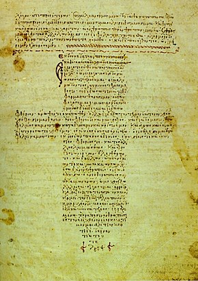
A 12th-century manuscript of the Hippocratic Oath in Greek, one of the most famous aspects of classical medicine that carried into later eras
The history of medicine is both a study of medicine throughout history as well as a multidisciplinary field of study that seeks to explore and understand medical practices, both past and present, throughout human societies.
The history of medicine is the study and documentation of the evolution of medical treatments, practices, and knowledge over time. Medical historians often draw from other humanities fields of study including economics, health sciences, sociology, and politics to better understand the institutions, practices, people, professions, and social systems that have shaped medicine. When a period which predates or lacks written sources regarding medicine, information is instead drawn from archaeological sources. This field tracks the evolution of human societies' approach to health, illness, and injury ranging from prehistory to the modern day, the events that shape these approaches, and their impact on populations. (Full article...)


General images -
-
 An animation of the changing density of productive vegetation on land (low in brown; heavy in dark green) and phytoplankton at the ocean surface (low in purple; high in yellow) (from Earth)
 -
 Image of the physical world, captured by the Hubble Space Telescope (from World)
 -
 Machu Picchu, Inca Empire, Peru
 -
 Carving of Persian and Median soldiers, Persepolis, Achaemenid Empire, 5th century BCE
 -
 Tracy Caldwell Dyson, a NASA astronaut, observing Earth from the Cupola module at the International Space Station on 11 September 2010 (from Earth)
 -
 A 580 million year old fossil of Spriggina floundensi, an animal from the Ediacaran period. Such life forms could have been ancestors to the many new forms that originated in the Cambrian Explosion. (from History of Earth)
 -
 An artist's impression of the Archean, the eon after Earth's formation, featuring round stromatolites, which are early oxygen-producing forms of life from billions of years ago. After the Late Heavy Bombardment, Earth's crust had cooled, its water-rich barren surface is marked by continents and volcanoes, with the Moon still orbiting Earth half as far as it is today, appearing 2.8 times larger and producing strong tides. (from Earth)
 -
 Angkor Wat temple complex, Cambodia, early 12th century
 -

-
 A computer-generated image mapping the prevalence of artificial satellites and space debris around Earth in geosynchronous and low Earth orbit (from Earth)
 -
 Vitruvian Man by Leonardo da Vinci epitomizes the advances in art and science seen during the Renaissance. (from History of Earth)
 -
 Tiktaalik, a fish with limb-like fins and a predecessor of tetrapods. Reconstruction from fossils about 375 million years old. (from History of Earth)
 -
 A composite image of artificial light emissions at night on a map of Earth (from Earth)
 -
 The pale orange dot, an artist's impression of the early Earth which might have appeared orange through its hazy methane rich prebiotic second atmosphere. Earth's atmosphere at this stage was somewhat comparable to today's atmosphere of Titan. (from History of Earth)
 -

-
 Earth's night-side upper atmosphere appearing from the bottom as bands of afterglow illuminating the troposphere in orange with silhouettes of clouds, and the stratosphere in white and blue. Next the mesosphere (pink area) extends to the orange and faintly green line of the lowest airglow, at about one hundred kilometers at the edge of space and the lower edge of the thermosphere (invisible). Continuing with green and red bands of aurorae stretching over several hundred kilometers. (from Earth)
 -
 A map of heat flow from Earth's interior to the surface of Earth's crust, mostly along the oceanic ridges (from Earth)
 -
 A reconstruction of human history based on fossil data. (from History of Earth)
 -
 Peopling of the world, the Southern Dispersal scenario
 -
 Chloroplasts in the cells of a moss (from History of Earth)
 -

-
 Artist's conception of Devonian flora (from History of Earth)
 -
 Earth's axial tilt causing different angles of seasonal illumination at different orbital positions around the Sun (from Earth)
 -
 Lithified stromatolites on the shores of Lake Thetis, Western Australia. Archean stromatolites are the first direct fossil traces of life on Earth. (from History of Earth)
 -
 Artist's rendition of an oxinated fully-frozen Snowball Earth with no remaining liquid surface water. (from History of Earth)
 -
Artist's impression of Earth during the later Archean, the largely cooled planetary crust and water-rich barren surface, marked by volcanoes and continents, features already round microbialites. The Moon, still orbiting Earth much closer than today and still dominating Earth's sky, produced strong tides. (from History of Earth)
-
 Standing Buddha from Gandhara, 2nd century CE
 -
 Satellite time lapse imagery of Earth's rotation showing axis tilt (from Earth)
 -
 A view of Earth with its global ocean and cloud cover, which dominate Earth's surface and hydrosphere; at Earth's polar regions, its hydrosphere forms larger areas of ice cover. (from Earth)
 -
 Graph showing range of estimated partial pressure of atmospheric oxygen through geologic time (from History of Earth)
 -
 A banded iron formation from the 3.15 Ga Moodies Group, Barberton Greenstone Belt, South Africa. Red layers represent the times when oxygen was available; gray layers were formed in anoxic circumstances. (from History of Earth)
 -

-
 Great Mosque of Kairouan, Tunisia, founded 670 CE
 -
 Earth's western hemisphere showing topography relative to Earth's center instead of to mean sea level, as in common topographic maps (from Earth)
 -
 Artist's impression of a Hadean landscape with the relatively newly formed Moon still looming closely over Earth and both bodies sustaining strong volcanism. (from History of Earth)
 -
 Chennakesava Temple, Belur, India
 -
 Dinosaurs were the dominant terrestrial vertebrates throughout most of the Mesozoic (from History of Earth)
 -

-
 Japanese depiction of a Portuguese carrack. European maritime innovations led to proto-globalization.
 -

-
 "Lucy", the first Australopithecus afarensis skeleton found, was only 1.06 m (3 ft 6 in) tall.
 -
 Trilobites first appeared during the Cambrian period and were among the most widespread and diverse groups of Paleozoic organisms. (from History of Earth)
 -
 A reconstruction of Pannotia (550 Ma). (from History of Earth)
 -
 Last Moon landing: Apollo 17 (1972)
 -
 A composite image of Earth, with its different types of surface discernible: Earth's surface dominating Ocean (blue), Africa with lush (green) to dry (brown) land and Earth's polar ice in the form of Antarctic sea ice (grey) covering the Antarctic or Southern Ocean and the Antarctic ice sheet (white) covering Antarctica. (from Earth)
 -
 Cross-section through a liposome (from History of Earth)
 -
 Artist's conception of Hadean Eon Earth, when it was much hotter and inhospitable to all forms of life. (from History of Earth)
 -

-
 Yggdrasil, an attempt to reconstruct the Norse world tree which connects the heavens, the world, and the underworld. (from World)
 -
 Ming dynasty section, Great Wall of China
 -
 Geologic map of North America, color-coded by age. From most recent to oldest, age is indicated by yellow, green, blue, and red. The reds and pinks indicate rock from the Archean.
 -
 Olmec colossal head, now at the Museo de Antropología de Xalapa
 -
 Great Pyramids of Giza, Egypt
 -
 A schematic view of Earth's magnetosphere with solar wind flowing from left to right (from Earth)
 -
 A 2012 artistic impression of the early Solar System's protoplanetary disk from which Earth and other Solar System bodies were formed (from Earth)
 -
 An artist's impression of ice age Earth at glacial maximum. (from History of Earth)
 -
 Pillar erected by Ashoka, a Mauryan Emperor in India
 -

-
 A pillar at Göbekli Tepe
 -
Pale orange dot, an artist's impression of Early Earth, featuring its tinted orange methane-rich early atmosphere (from Earth)
-
 13th-century French historiated initial with the three classes of medieval society: those who prayed (the clergy), those who fought (the knights), and those who worked (the peasantry) (from Human history)
 -
 Artist's impression of the enormous collision that probably formed the Moon (from History of Earth)
 -
 Battle during the 1281 Mongol invasion of Japan
 -

-
 Shanghai. China urbanized rapidly in the 21st century.
 -
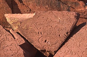
 Cuneiform inscription, eastern Turkey
 -
 Pangaea was a supercontinent that existed from about 300 to 180 Ma. The outlines of the modern continents and other landmasses are indicated on this map. (from History of Earth)
 -
 Florence, birthplace of the Italian Renaissance
 -
 Empires of the world in 1898
 -
 Ajloun Castle, Jordan
 -
 Change in average surface air temperature and drivers for that change. Human activity has caused increased temperatures, with natural forces adding some variability. (from Earth)
 -
 Earth's history with time-spans of the eons to scale. Ma means "million years ago". (from History of Earth)
 -
 An artist's rendering of a protoplanetary disk (from History of Earth)
 -
 COVID-19 pandemic, 2020 (from Human history)
 -

-

-
 Earth's land use for human agriculture in 2019 (from Earth)
 -
 Notre-Dame de Paris, France
 -
 Taj Mahal, Mughal Empire, India
 -
 First airplane, the Wright Flyer, flew on 17 December 1903.
 -
 Benin Bronze head from Nigeria
 -

-
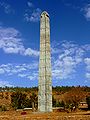 Obelisk of Axum, Ethiopia
 -
 Fall of the Berlin Wall, 1989
 -
 The replicator in virtually all known life is deoxyribonucleic acid. DNA is far more complex than the original replicator and its replication systems are highly elaborate. (from History of Earth)
 -
 A view of Earth with different layers of its atmosphere visible: the troposphere with its clouds casting shadows, a band of stratospheric blue sky at the horizon, and a line of green airglow of the lower thermosphere around an altitude of 100 km, at the edge of space (from Earth)
 -


.jpg)
.jpg)

.svg)


.jpeg)


.png)


.jpg)


Megacities of the world -

Tokyo (/ˈtoʊkioʊ/; Japanese: 東京, Tōkyō, [toːkʲoː] ), officially the Tokyo Metropolis (東京都, Tōkyō-to), is the capital of Japan and one of the most populous cities in the world, with a population of over 14 million residents as of 2023 and the second-most-populated capital in the world. The Greater Tokyo Area, which includes Tokyo and parts of six neighboring prefectures, is the most-populous metropolitan area in the world, with 41 million residents as of 2024[update].
Located at the head of Tokyo Bay, Tokyo is part of the Kantō region on the central coast of Honshu, Japan's largest island. Tokyo serves as Japan's economic center and the seat of both the Japanese government and the Emperor of Japan. The Tokyo Metropolitan Government administers Tokyo's central 23 special wards (which formerly made up Tokyo City), various commuter towns and suburbs in its western area, and two outlying island chains known as the Tokyo Islands. Despite most of the world recognizing Tokyo as a city, since 1943 its governing structure has been more akin to a prefecture, with an accompanying Governor and Assembly taking precedence over the smaller municipal governments which make up the metropolis. Notable special wards in Tokyo include Chiyoda, the site of the National Diet Building and the Tokyo Imperial Palace; Shinjuku, the city's administrative center; and Shibuya, a commercial, cultural, and business hub in the city. (Full article...)Did you know -

- ... that the archaeologist Alan Wace worked undercover for British intelligence during both world wars?
- ... that Forbes named German chancellor Angela Merkel the world's most powerful woman fourteen times?
- ... that the final of the 2009 IBSF women's snooker championship was interrupted so that drug tests could be conducted on the players?
- ... that the ancient Greek game polis is one of the world's oldest known strategy games?
- ... that Henry Clay Frick would not take World War I as an excuse for delays in the construction of his New York City house?
- ... that the Te'omim Cave in Israel was home to a Bronze Age alabaster quarry, a refuge cave during the Jewish–Roman wars, and a possible center for necromantic activity in late antiquity?
- ... that Rhapsody was the hardest traditional climbing route in the world?
- ... that a photograph of Frances "the Shape" Vorne wearing a swimsuit made from remnants of a captured Nazi parachute was one of the most sought-after pin-ups of World War II?
Countries of the world -

The Comoros, officially the Union of the Comoros, is an archipelagic country made up of three islands in Southeastern Africa, located at the northern end of the Mozambique Channel in the Indian Ocean. Its capital and largest city is Moroni. The religion of the majority of the population, and the official state religion, is Sunni Islam. Comoros proclaimed its independence from France on 6 July 1975. The Comoros is the only country of the Arab League which is entirely in the Southern Hemisphere. It is a member state of the African Union, the Organisation internationale de la Francophonie, the Organisation of Islamic Co-operation, and the Indian Ocean Commission. The country has three official languages: Shikomori, French and Arabic.
At 1,659 km2 (641 sq mi), the Comoros is the third-smallest African country by area. In 2019, its population was estimated to be 850,886.0 The sovereign state consists of three major islands and numerous smaller islands, all of the volcanic Comoro Islands with the exception of Mayotte. Mayotte voted against independence from France in a referendum in 1974, and continues to be administered by France as an overseas department. France has vetoed a United Nations Security Council resolution that would have affirmed Comorian sovereignty over the island. Mayotte became an overseas department and a region of France in 2011 following a referendum which was passed overwhelmingly. (Full article...)Related portals
Protected areas of the world -
-
Desert landscape in Qatar
Protected areas of Qatar include:- Al Reem Biosphere Preserve (designated in 2007) is part of the World Network of Biosphere Reserves in the Arab States
- Al Shahaniyah Park in Al-Shahaniya
- Al Thakira Nature Reserve in Al Thakhira
- Al Wabra Wildlife Preservation
- Dahl Al Hammam Park, a sinkhole in Doha (entrance to the hole is now closed to the public)
- Khor Al Adaid Reserve in Khor Al Adaid
- Khor Al Adaid Fish Sanctuary
- Mudhlem Cave in Mukaynis
- Musfer Sinkhole in Salwa
- Ras Abrouq Nature Reserve (also known as Bir Zekreet (Zekreet Beach)) in Ras Abrouq
- Ras Ushairij Gazelle Conservation Park
- Umm Tais National Park
-
Protected areas of Indonesia comprise both terrestrial and marine environments in any of the six IUCN Protected Area categories. There are over 500 protected areas in Indonesia, of which 54 National Parks cover 16.4 million ha, and another 527 nature and game reserves cover a further 28.3 million ha. The total protected land area represents over 15% of Indonesia's landmass. Marine Protected Areas comprise over 15.7 million ha representing ca. 5% of territorial waters. (Full article...)
-
Cadw is the historic environment service of the Welsh Government which manages historical buildings and ancient monuments in Wales. (Full article...)
-
Rock carvings at the Ewaninga Rock Carvings Conservation Reserve
The protected areas of the Northern Territory consists of protected areas managed by the governments of the Northern Territory and Australia and private organisations with a reported total area of 335,527 square kilometres (129,548 sq mi) being 24.8% of the total area of the Northern Territory of Australia. (Full article...) -
This is a list of protected areas of Romania.
About 5.18% of the area of Romania has a protected status (12,360 km2), including the Danube Delta, which makes half of these areas (2.43% of Romania's area). (Full article...) -

Vegetation outside Goz Beïda
The wildlife of Chad is composed of its flora and fauna. Bush elephants, West African lions, buffalo, hippopotamuses, Kordofan giraffes, antelopes, African leopards, cheetahs, hyenas, and many species of snakes are found there, although most large carnivore populations have been drastically reduced since the early 20th century. Elephant poaching, particularly in the south of the country in areas such as Zakouma National Park, is a severe problem. (Full article...) -
Protected areas of Australia include Commonwealth and off-shore protected areas managed by the Australian government, as well as protected areas within each of the six states of Australia and two self-governing territories, the Australian Capital Territory and the Northern Territory, which are managed by the eight state and territory governments.
Commonwealth and off-shore protected areas in the Australian Capital Territory, the Northern Territory, the Christmas Island Territory, the Cocos (Keeling) Islands Territory, the Norfolk Island Territory and the Australian Antarctic Territory are managed by Director of National Parks, an agency within the Department of the Environment and Energy, with the exception of the Great Barrier Reef Marine Park, which is managed by the Great Barrier Reef Marine Park Authority, a separate body within the department. (Full article...) -

Map of Georgia
The protected areas of Georgia cover almost one million acres (4,000 km2) of the state. These areas are managed by different federal and state level authorities and receive varying levels of protection. Some areas are managed as wilderness while others are operated with acceptable commercial exploitation. On the Federal level, Georgia contains 1 Biosphere Reserve, 15 National Park Service Managed Sites, 1 National Forest and 8 Wildlife Refuges. Georgia is home to 63 state parks, 48 of which are state parks and 15 that are National Historic Sites, and many state wildlife preserves, under the supervision of the Georgia Department of Parks and Recreation, a division of the Georgia Department of Natural Resources. (Full article...) -
The mountain of Stob Binnein lies in the Loch Lomond and The Trossachs National Park.
Many parts of Scotland are protected in accordance with a number of national and international designations because of their environmental, historical or cultural value. Protected areas can be divided according to the type of resource which each seeks to protect. NatureScot has various roles in the delivery of many environmental designations in Scotland, i.e. those aimed at protecting flora and fauna, scenic qualities and geological features. Historic Environment Scotland is responsible for designations that protect sites of historic and cultural importance. Some international designations, such as World Heritage Sites, can cover both categories of site.
The various designations overlap considerably with many protected areas being covered by multiple designations with different boundaries. (Full article...) -

Redwood grove in Redwood National Park
According to the California Protected Areas Database (CPAD), in the state of California, United States, there are over 14,000 inventoried protected areas administered by public agencies and non-profits. In addition, there are private conservation areas and other easements. They include almost one-third of California's scenic coastline, including coastal wetlands, estuaries, beaches, and dune systems. The California State Parks system alone has 270 units and covers 1.3 million acres (5,300 km2), with over 280 miles (450 km) of coastline, 625 miles (1,006 km) of lake and river frontage, nearly 18,000 campsites, and 3,000 miles (5,000 km) of hiking, biking, and equestrian trails.
Obtaining an accurate total of all protected land in California and elsewhere is a complex task. Many parcels have inholdings, private lands within the protected areas, which may or may not be accounted for when calculating total area. Also, occasionally one parcel of land is included in two or more inventories. Over 90% of Yosemite National Park for example, is listed both as wilderness by the National Wilderness Preservation System, and as national park land by the National Park Service. The Cosumnes River Preserve is an extreme example, owned and managed by a handful of public agencies and private landowners, including the Bureau of Land Management, the County of Sacramento and The Nature Conservancy. Despite the difficulties, the CPAD gives the total area of protected land at 49,294,000 acres (199,490 km2), or 47.05% of the state (not including easements); a considerable amount for the most populous state in the country. (Full article...) -
The Protected areas of New South Wales include both terrestrial and marine protected areas. As of June 2020[update] there are 225 national parks in New South Wales. A number established since the late 1970s followed campaigns by local residents and environmentalists.
Based on the Collaborative Australian Protected Area Database (CAPAD) 2020 data there are 2136 separate terrestrial protected areas with a total land area of 7,696,641 hectares (19,018,810 acres) (9.61% of the state's area). CAPAD data also shows 18 marine protected areas with a total area of 348,849 hectares (862,020 acres), covering 39.63% of NSW waters. (Full article...) -
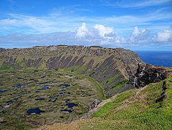
Rano Kau, Parque National Rapa Nui, Easter Island
The protected areas of Chile are areas that have natural beauty or significant historical value protected by the government of Chile. These protected areas cover over 140,000 km2 (54,054 sq mi), which is 19% of the territory of Chile. The National System of Protected Wild Areas (SNASPE by its Spanish acronym) is regulated by law #18,362 passed in 1984, and administered by the National Forest Corporation (CONAF).
There are three types of territories: (Full article...) -

Overview of IUCN Protected area - WAP (W, Arli, Pendjari) area - Niger, Burkina Faso, and Benin
The following is a list of protected areas of Burkina Faso. (Full article...) -
-
Protected areas of Tamil Nadu cover an area of 3,305 km2 (1,276 sq mi), constituting 2.54% of the geographic area and 15% of the 22,643 km2 (8,743 sq mi) recorded forest area of the state of Tamil Nadu in South India. It ranks 14th among all the states and union territories of India in terms of total protected area.
Protected areas in South India were created from private hunting grounds of the erstwhile Maharajas of the princely states. Mudumalai National Park was established in 1940 and was the first modern wildlife sanctuary in South India. The protected areas are administered by the Ministry of Environment and Forests of Government of India and the Tamil Nadu Forest Department. (Full article...)
.jpg)


Selected world maps
-
 1516 map of the world by Martin Waldseemüller
 -
 Index map from the International Map of the World (1:1,000,000 scale)
 -
 United Nations Human Development Index map by country (2016)
 -
 The Goode homolosine projection is a pseudocylindrical, equal-area, composite map projection used for world maps.
 -
 Mollweide projection of the world
 -
 Time zones of the world
 -
 Only a few of the largest large igneous provinces appear (coloured dark purple) on this geological map, which depicts crustal geologic provinces as seen in seismic refraction data
 -
 The world map by Gerardus Mercator (1569), the first map in the well-known Mercator projection
 -
 A plate tectonics map with volcano locations indicated with red circles


World records
- List of Olympic records in athletics
- List of world records in athletics
- List of junior world records in athletics
- List of world records in masters athletics
- List of world youth bests in athletics
- List of IPC world records in athletics
- List of world records in canoeing
- List of world records in chess
- List of cycling records
- List of world records in track cycling
- List of world records in finswimming
- List of world records in juggling
- List of world records in rowing
- List of world records in speed skating
- List of world records in swimming
- List of IPC world records in swimming
- List of world records in Olympic weightlifting
Topics

Continents of Earth | ||||||||
|---|---|---|---|---|---|---|---|---|
| ||||||||
| ||||||||
| ||||||||


| Cenozoic Era (present–66.0 Ma) |
| ||||||||||||
|---|---|---|---|---|---|---|---|---|---|---|---|---|---|
| Mesozoic Era (66.0–252 Ma) |
| ||||||||||||
| Paleozoic Era (252–539 Ma) |
| ||||||||||||
| Proterozoic Eon (539 Ma–2.5 Ga) |
| ||||||||||||
| Archean Eon (2.5–4 Ga) | |||||||||||||
| Hadean Eon (4–4.6 Ga) | |||||||||||||
ka = kiloannum (thousands years ago); Ma = megaannum (millions years ago); Ga = gigaannum (billions years ago). See also: Geologic time scale • | |||||||||||||
| Locations | ||
|---|---|---|
| Related | ||

| |||||||||||||||||||
| |||||||||||||||||||
| |||||||||||||||||||

Economic classification of countries | |||||
|---|---|---|---|---|---|
| Three-World Model | |||||
| Gross domestic product (GDP) |
| ||||
| Gross national income (GNI) | |||||
| Wages | |||||
| Wealth | |||||
| Other national accounts | |||||
| Human development | |||||
| Digital divide | |||||
| Net international investment position (NIIP) | |||||
| Technological |
| ||||
|---|---|---|---|---|---|
| Sociological | |||||
| Ecological |
| ||||
| Biological |
| ||||
| Astronomical | |||||
| Eschatological |
| ||||
| Others |
| ||||
| Fictional | |||||
| Organizations | |||||
Categories

Wikimedia
The following Wikimedia Foundation sister projects provide more on this subject:
-
 Commons
Free media repository -
 Wikibooks
Free textbooks and manuals -
 Wikidata
Free knowledge base -
 Wikinews
Free-content news -
 Wikiquote
Collection of quotations -
 Wikisource
Free-content library -
 Wikispecies
Directory of species -
 Wikiversity
Free learning tools -
 Wikivoyage
Free travel guide -
 Wiktionary
Dictionary and thesaurus


