
Chama, Huerfano County, Colorado
Chama, Colorado
Crestones | |
|---|---|
.JPG) Our Lady of Guadalupe Church in Chama (2024) | |
 Chama (Huerfano County) Location of Chama in Huerfano County, Colorado  Chama (Huerfano County) Chama (Huerfano County) (the United States) | |
| Coordinates: 37°43′8.02″N 105°17′56.02″W / 37.7188944°N 105.2988944°W | |
| Country | |
| State | Colorado |
| County | Huerfano |
| Elevation | 7,881 ft (2,402 m) |
| Time zone | UTC-7 (MST) |
| • Summer (DST) | UTC-6 (MDT) |
| ZIP code | 81040 |
| Area code | 719 |
| [1] | |
Chama, elevation 7,881 feet (2,402 meters), is an unincorporated community in Huerfano County, Colorado, United States.
History
[edit]The community was settled around 1869 and was originally called Crestones. The first settlers were from Chama, New Mexico. An old adobe church, called Our Lady of Guadalupe, still stands in the community.[2]
Geography
[edit]Chama is located southwest of Gardner, Colorado and on the east side of the Sangre de Cristo Range along County Road 575 in the Upper Huerfano River Valley.[1]
References
[edit]- ^ a b "Chama". Geographic Names Information System. United States Geological Survey, United States Department of the Interior. October 13, 1978. Retrieved October 2, 2024.
- ^ Christofferson, Nancy (November 12, 2020). "Settling the upper Huerfano". Huerfano World Journal. Archived from the original on October 2, 2024. Retrieved October 2, 2024.
Municipalities and communities of Huerfano County, Colorado, United States | ||
|---|---|---|
| City | 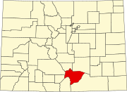 | |
| Town | ||
| CDP | ||
| Unincorporated communities | ||
| Ghost towns | ||