
File:Karte Oberlausitz.png

Size of this preview: 800 × 510 pixels. Other resolutions: 320 × 204 pixels | 640 × 408 pixels | 900 × 574 pixels.
Original file (900 × 574 pixels, file size: 201 KB, MIME type: image/png)
| This is a file from the Wikimedia Commons. Information from its description page there is shown below. Commons is a freely licensed media file repository. You can help. |
Summary
| Description |
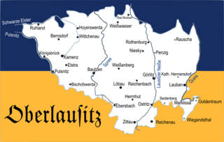
Deutsch: Historische Karte der Oberlausitz |
| Date | |
| Source | Own work |
| Author | Äberlausitzer |
| Other versions |
|


Licensing
| I, the copyright holder of this work, release this work into the public domain. This applies worldwide. In some countries this may not be legally possible; if so: I grant anyone the right to use this work for any purpose, without any conditions, unless such conditions are required by law. |
File history
Click on a date/time to view the file as it appeared at that time.
| Date/Time | Thumbnail | Dimensions | User | Comment | |
|---|---|---|---|---|---|
| current | 20:31, 17 November 2010 | | 900 × 574 (201 KB) | Äberlausitzer | {{Information |Description={{de|1=Historische Karte der Oberlausitz}} |Source={{own}} |Author=Äberlausitzer |Date=17.11.2010 |Permission= |other_versions= }} |
File usage
The following page uses this file:
Global file usage
The following other wikis use this file:
- Usage on bg.wikipedia.org
- Usage on cs.wikipedia.org
- Usage on da.wikipedia.org
- Usage on de.wikipedia.org
- Usage on eo.wikipedia.org
- Usage on fr.wikipedia.org
- Usage on it.wikipedia.org
- Usage on it.wikivoyage.org
- Usage on nl.wikipedia.org
- Usage on no.wikipedia.org
- Usage on pl.wikipedia.org
- Usage on sr.wikipedia.org
- Usage on sv.wikipedia.org
- Usage on szl.wikipedia.org
- Usage on tr.wikipedia.org
- Usage on uk.wikipedia.org
- Usage on zh.wikipedia.org