
File:Hessel Gerritsz 1622 map of the Pacific - closeup 'Illas de Salomon'.png

Size of this preview: 800 × 402 pixels. Other resolutions: 320 × 161 pixels | 640 × 322 pixels | 1,203 × 605 pixels.
Original file (1,203 × 605 pixels, file size: 1.63 MB, MIME type: image/png)
| This is a file from the Wikimedia Commons. Information from its description page there is shown below. Commons is a freely licensed media file repository. You can help. |
Summary
| Description |
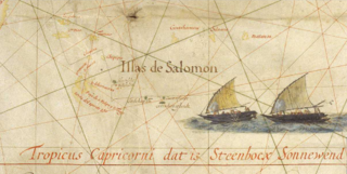
Français : Extrait de la carte du Pacifique d'Hessel Gerritsz (1622), montrant les "îles Salomon" ainsi que 5 îles découvertes par Jacob Le Maire et Willem Schouten en 1616 :
English: Close-up of the 1622 Map of the Pacific by Hessel Gerritsz showing the 'Solomon Islands' (Illas Salomon) as well as 5 islands discovered by Jacob le Maire and Willem Schouten in 1616:
|
| Date | |
| Source | http://expositions.bnf.fr/marine/grand/por_142.htm |
| Author | Hessel Gerritsz |
| Other versions |
File:Hessel_Gerritsz_Pacific_1622.jpg
|

Licensing
This work is in the public domain in the United States because it was published (or registered with the U.S. Copyright Office) before January 1, 1929.
Public domain works must be out of copyright in both the United States and in the source country of the work in order to be hosted on the Commons. If the work is not a U.S. work, the file must have an additional copyright tag indicating the copyright status in the source country.
Note: This tag should not be used for sound recordings. |
|
This work is in the public domain in its country of origin and other countries and areas where the copyright term is the author's life plus 70 years or fewer. | |
| This file has been identified as being free of known restrictions under copyright law, including all related and neighboring rights. | |
File history
Click on a date/time to view the file as it appeared at that time.
| Date/Time | Thumbnail | Dimensions | User | Comment | |
|---|---|---|---|---|---|
| current | 13:51, 17 April 2017 | | 1,203 × 605 (1.63 MB) | Skimel | User created page with UploadWizard |
File usage
The following page uses this file:
Global file usage
The following other wikis use this file: