
File:CityRail inner map.png

Size of this preview: 600 × 600 pixels. Other resolutions: 240 × 240 pixels | 480 × 480 pixels | 850 × 850 pixels.
Original file (850 × 850 pixels, file size: 224 KB, MIME type: image/png)
| This is a file from the Wikimedia Commons. Information from its description page there is shown below. Commons is a freely licensed media file repository. You can help. |
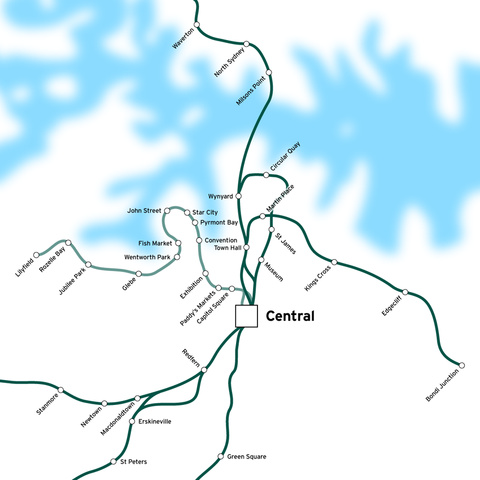
| Description | Rail network in the inner suburbs of Sydney, Australia. CityRail commuter train lines are shown in dark green. Metro Light Rail tram line shown in light green. | ||
| Source | en:Image:CityRail_inner_map.png | ||
| Author | en:User:Joestella | ||
| Permission (Reusing this file) |
|
File history
Click on a date/time to view the file as it appeared at that time.
| Date/Time | Thumbnail | Dimensions | User | Comment | |
|---|---|---|---|---|---|
| current | 07:44, 15 April 2007 | | 850 × 850 (224 KB) | Essolo | {{Information |Description=Rail network in the inner suburbs of Sydney, Australia. CityRail commuter train lines are shown in dark green. Metro Light Rail tram line shown in light green. |Source=en:Image:CityRail_inner_map.png |Date= |Author=[[:en:Us |
File usage
No pages on the English Wikipedia use this file (pages on other projects are not listed).